After a short break catching up on some admin and visiting customers in the field I am pleased to present the fourth instalment of the Guide to Wildlife Tracking series. Please contact me at Jason@awetelemetry.co.za for a full pdf version.
GNSS (GPS) UHF
Logging with local radio delivery
Technology summary
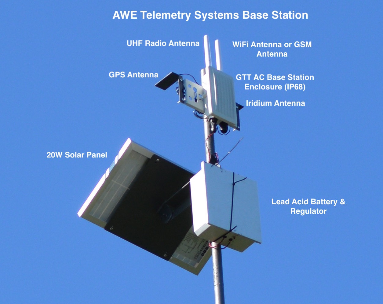
GNSS UHF collars, also known as UHF download collars, offer fully remote automated data collection. Depending on the system deployed, the delivery of the data could be automatic to a network of ‘base stations’ or data could be manually downloaded wirelessly from the collar by field personnel. Location data is autonomously collected by the tracking device and stored in memory on the tracking device or immediately sent to a base station. GNSS UHF tracking devices have been around for a long time and are small and low power enough to be used on small animals. The greatest challenges with this technology option are the need of line-of-sight between the tracking device and base station or download receiver, the practical range and of the radio link and the download speed that is achievable via the radio link. It can be a cost-effective option for the collection of location data over time as it requires no manual effort from the user for data collection but if there is no base station infrastructure in place, the data needs to be manually downloaded in the field by the user.
How do GNSS UHF tracking devices work?
The Global Positioning System (GPS) was the first commercially available Global Navigation Satellite System (GNSS) available – and is still the most widely used. There are more systems in operation such as Galileo, BeiDou and GLONASS. Modern GNSS receiver modules are capable of using multiple of these systems to improve performance in acquiring locations.
Ultra High Frequency (UHF) radios generally operate in the Industrial, Scientific and Medical (ISM) radio frequency band. The ISM band allows for licence-free operation and the allowed frequency and duty cycle depend on the regulations of each country. The most common frequency bands used in UHF radios are around 433 MHz, 868 MHz or 900 MHz. The correct frequency needs to be selected to comply with local regulations.
GNSS UHF tracking devices combine a GNSS receiver with UHF radio module and some memory for data storage. The GNSS receiver module acquires location coordinates and time from GNSS systems such as GPS. Once a location is acquired the tracking device stores it in memory with the time and date. Collected data is sent to a computing platform on the Internet via a base station network if installed, or may be downloaded wirelessly from the tracking device in the field – depending on the system deployed. The platform could make the data available to the user via email, an Application Programming Interface (API) or via a web portal.
Typically GNSS UHF tracking devices are configured to acquire locations on a set schedule and can autonomously download data to base station infrastructure if in place. Alternatively the tracking devices can be downloaded opportunistically in the field with specialised receivers. Each brand of GNSS UHF tracking device may have its own proprietary method of operating and receivers required for downloading data. Some GNSS UHF tracking device operate on standardised protocols and may be compatible with base stations across brands.
Some common types of UHF solutions available are:
Low Power Wide Area Network
There are various kinds of Low Power Wide Area Network radio technologies around. The key concept of these technologies is to send data at very low data rates in a very narrow frequency band e.g. SigFox, or by spreading signals in multiple bands across a broader spectrum e.g. LoRaWAN. The main aim is to improve the sensitivity of the receiver so that out-of-band noise has less of an impact on the receive signal. Typical maximum practical range when there is ‘line-of-sight’ between the transmitter and receiver is in the order of 15 km to 20 km. This is vastly reduced when there is obstruction in the transmit path. The time to send up a single location at such a range is in the order of two seconds, making it impractical to download a lot of data using these technologies. In some cases the modulation technique is changed when the signal strength is high to provide for slow data rate when far from a receiver and higher data rate when nearer to the receiver.
LPWAN networks could either be licensed, commercially operated networks such as SigFox or self operated networks in the ISM radio band such as LoRaWAN. In some cases commercial entities offer LoRaWAN networks as a service.
In a LPWAN network the end device, called a ‘node’, typically reports its data to a ‘base station’ on set interval and waits a short period for any commands that my be queued for it by the network.
There are some factors to consider when using LPWAN technology for wildlife tracking.
- As there is unlikely to be a commercial LPWAN operator in rural areas, a LPWAN network consisting of multiple base stations with Internet connections will need to be installed and maintained in the area.
- A tracking platform service provider will need to be involved so that data from LPWAN networks can be collected, handled and made available to the user via a web interface.
- Data downloading from devices may be challenging due to the slow data rate. This comes into play when animals roam out of range of a network and return.
- Radio range in dense vegetation or mountainous terrain will be poor and more base stations are required in these conditions.
- Generally LPWAN devices do not offer regular opportunities for communication to the device, and the user has to queue commands on the network for delivery at the next scheduled transmission from the tracking device.
- LPWAN technologies comply to a standard and theoretically once there is a network available, different brands of tracking devices could be configured on the network if allowed by the network provider.
Traditional modulation such as FSK or OOK
GNSS UHF tracking devices that make use of traditional modulation such as Frequency Shift Keying (FSK) or On-Off Keying (OOK) in their radio modules are also available on the market. These systems generally do not get as much range as LPWAN radios can, but can nonetheless still get decent range of up to 10 km or more in line-of-sight conditions. The radio links are also typically configured for higher throughput. Depending on the system deployed, these tracking devices can automatically report their locations or download previously stored locations when in range of a base station, or a user can opportunistically download data directly from the tracking device when in range. Some of these systems have been used to great success as an alternative to GNSS Satellite tracking devices in areas devoid of cellular networks. Some points of consideration for GNSS UHF tracking devices using traditional radio technologies:
- Radio range in dense vegetation is poor.
- Systems are proprietary and tracking devices from one company will not be compatible with base stations or receivers from another company.
- Depending on the system, these devices offer more regular opportunities to send commands to the tracking devices.
- Download speeds are much higher than LPWAN devices, but can still take long if there are many points that need to be downloaded.
- Some systems employing this technology are suitable for animals that leave the network range and return as they have the capability of downloading logged data.
How do you track an animal with a GNSS UHF device?
Data points from GNSS UHF tracking devices are automatically uploaded from the device via the radio network and back down to a service provider’s platform on the Internet. Some systems require the user to retrieve the collected data from a base station if there is no means of connecting the base station to the Internet. Alternatively, if a traditional UHF radio system is used, field personnel can download data in the field with a UHF data downloader. GNSS UHF tracking devices are often also fitted with a VHF transmitter so that field personnel can track the animal with a VHF receiver and, when in range, can then do data downloads via UHF radio. Traditional GNSS UHF tracking devices can be used without the need to maintain a network of base stations, but it is then required that field personnel manually download collected data wirelessly from the tracking devices. Some GNSS UHF tracking devices allow the user to request a current location from the device. This feature is very useful when there is a need to physically observe an animal. Once in range of the tracking device, a new locations is requested, and the exact GPS coordinates are returned to the UHF receiver after about a minute. These coordinates can simply be plugged into a GPS device or smartphone to guide the field personnel to the exact location of the animal – no need to continuously sweep the horizon for VHF signal or try to estimate how far it is by the signal strength. This feature is however not available on GNSS UHF devices that make use of LPWAN networks and the user generally has to wait for the tracking device to send its latest location at the next scheduled time.
GNSS considerations
The maximum accuracy of a civilian GNSS receiver is about 2 m. In practice however the accuracy of acquired locations are typically 5 m to 10 m in good conditions. Each acquired location has a varying degree of accuracy depending on where the satellites used for the acquisition are located. The highest accuracy can be achieved if the GNSS receiver’s antenna has an unobstructed vantage point to the full sky. In these ideal conditions multiple satellites from different segments of the sky are used in calculating the location – providing quick and accurate results. If the GNSS antenna is partially obstructed by terrain or vegetation, or if it is oriented away from the open sky, the GNSS receiver will take longer to acquire a location and the accuracy of that location will be reduced because the satellites used may be within the same area of sky, which reduces the ability to get an accurate ‘fix’. Good GNSS devices measure the accuracy of each location and provide a horizontal dilution of precision (HDOP) which gives an indication of the possible error on the acquired location. Because of the high cost of satellite data transmission, not all GNSS Satellite tracking devices send HDOP data with each point, but rather use the HDOP value as part of a criteria to determine whether a location is accurate enough to store for upload.
GNSS UHF device power consumption
GNSS UHF devices can be very power efficient depending on the brand and how they are configured. There are two primary elements that contribute to to battery draw namely the GNSS receiver and the radio module.
GNSS receiver power consumption
The amount of battery power consumed by a GNSS receiver whilst acquiring satellite data from the GNSS system, and the determination of location depends on the brand and components used and whether an active or passive antenna is connected. Active antennas compensate for signal loss in the feeding cable between the GNSS receiver and the antenna element. Active antennas are generally not required where short antenna cables are used – but this is dependent on the design of the tracking device or collar.
Most GNSS receivers store satellite ephemeris data from the GNSS satellites so that when they start up again within a certain period of time (two hours or less), some of the data is still valid and the time to get a location – known as Time to Fix (TTF) – is shorter than it would be when starting with no data – known as Time to First Fix (TTFF). Every two hours or so the receiver needs to replenish its ephemeris data to reduce any future TTF. When a GNSS device is started up in good sky view within a minute of its last ‘fix’, it could get a new ‘fix’ in a TTF of 1 second. This is called a ‘hot start’. When starting up 5 minutes to 2 hours after refreshing its ephemeris data, a GNSS receiver can ‘fix’ in a TTF of 5 to 15 seconds – known as a ‘warm start’. When starting up with no ephemeris data or with data that is more than 2 hours old most GNSS receivers can get a new fix in a TTFF of less than 30 seconds in very good sky view conditions – known as a ‘cold start’. These TTF and TTFF times (typically advertised on the GNSS receiver data sheet) are best-case times. In reality it is unlikely for the GNSS receiver to start up in ideal sky view conditions when fitted to an animal. Any partial obstruction of the sky or adverse orientation of the antenna has an adverse effect on the TTFF and TTF. GNSS cellular tracking devices are configured to allow a finite amount of time for the GNSS receiver to successfully acquire a location. Depending on the device the time allowed to fix could be from 1 minute up to 5 minutes, after which it ‘times out’ and registers no position for that time. GNSS receivers that are fitted to animals that frequent dense vegetation, canyons or ravines can easily consume more than 4 times the power when compared those fitted to animals that roam open grass plains for example. Cloud cover and precipitation also attenuates signals from GNSS satellites – increasing TTF and therefore also the power consumption.
Radio module power consumption
The other contributor to power consumption is the Radio module. UHF tracking devices can be configured to be very frugal on battery usage as the radio transmissions can be configured to be spaced apart much further than VHF transmitters for example. Dense vegetation and mountainous terrain does not affect power consumption by the UHF radio although it will affect power consumption of the GNSS receiver.
Suitability of GNSS UHF devices for different applications
GNSS UHF tracking devices can be quite small and are suitable for tracking small to medium-sized to very large animals. For the purpose of comparison with the other technologies discussed in this guide we will consider the same applications again.
Physically finding an animal
When it is required to visually monitor an animal or a group of animals, the efficacy of GNSS UHF devices depends on a few factors. If the terrain frequented by the animal fitted with the tracking device has sparse vegetation and base stations fully cover the area, it is very likely that the device will regularly report its location and field personnel can simply go to the latest location and start searching for VHF signal, or alternatively get an updated location from the tracking device if this feature is supported. If there are insufficient base stations to cover the entire area the best solution would be to use the GNSS UHF device in conjunction with a VHF transmitter to locate the animal. The procedure is best started by finding VHF signal. Once VHF signal is obtained the field personnel can move in the direction of the animal until observed. If the UHF device has the capability to provide a requested location, it can significantly shorten the search time because the user can request the exact location as soon as they are in range of the UHF radio.
Collecting location data
Good GNSS UHF tracking devices capture and store location data so that it can either be automatically uploaded to a platform via a network of base stations, or field personnel can download the data via a radio link when within range. Some however do not offer this feature and unsuccessful uplinks are never recovered. When compared to VHF transmitters where data collection is manual:
- The act of physically tracking the animal is not regularly required and the use of the technology does not massively alter its behaviour due to the field personnel’s proximity to the animal.
- Each location point is automatically captured by the GNSS receiver and it is therefore easy to get a rich data set.
- The collection of location information does not consume a lot of costly resources. Data can be manually downloaded regularly, or once at the end of a study period. Some systems deliver data automatically if there is a network of base stations to deliver the information.
- As apposed to VHF transmitters, getting animal locations at night time from a GNSS UHF tracking device is no more challenging than getting them in the day. This allows for safer studies on nocturnal animals. It is however a possibility that data downloads can be difficult in the day if the animals are underground or hide in dense vegetation during the day.
- The efficacy of GNSS UHF collars are dependent on terrain and animal behaviour.
Collecting other data
If more information such as activity level or temperature is needed, some types of GNSS UHF tracking device can include that in the data set with minimal impact on battery consumption.
GNSS UHF tracking collar costs
GNSS UHF tracking collars are the second least expensive tracking collars in this guide, but there may be additional costs in maintaining a network of base stations. The impact of base station outages can be very large if multiple collars rely on the infrastructure.
Cost of Equipment – Low to High
The cost of a GNSS UHF collar is low when compared to other solutions in this guide. In addition to the collar, the user will need to purchase a UHF receiver and/or configure a network of base stations – which can be costly. Maintenance of the network is another cost that needs to be considered.
Cost of Deployment – High
Fitting and removing tracking collars to wildlife is very expensive. Depending on the animal being collared, various techniques are used to capture and often tranquillise the animal before fitting the collar. It is sometimes necessary to charter spotter airplanes, helicopters and specialised wildlife veterinarians to get the job done. The total cost in resources to locate, tranquillise and fit tracking devices to animals can sometimes exceed the costs of the tracking equipment.
Service Fees – Zero to Medium
There may be a service fee associated with GNSS UHF collars if there is a network of base stations involved. The fees generally cover the cost of the provider’s platform, maintenance fees for the base stations and communications subscriptions such as cellular contracts or satellite service subscriptions for the base station backhaul. Base station fees are generally charged on a monthly basis. Collar access fees may be charged monthly or bundled into the upfront cost of the collar. There should be no fees charged for collars in the absence of a base station network.
Cost of Use – Medium to High
During normal operation there is no intervention required for a GNSS UHF tracking collar to acquire location data. If there is a network of base stations, the data should be automatically delivered to the user. Base station networks are costly to maintain and there are likely to be service and management fees involved for such a network. In the absence of base stations, field personnel have to manually download data from the collars from time to time. These devices can collect a lot of data and provide rich data sets.
Total Cost – Medium to High
When considering all costs, GNSS UHF tracking collars are efficient at gathering data because this is done automatically without any manual field work required. There are however costs in accessing the data – either through manual downloads in the field, or as a result of maintenance and service fees associated with operating a network of base stations.
GNSS UHF Technology rating
Reliability – Very Good to Medium
GNSS UHF collars can be very reliable. Because the tracking devices are small in size, they can be contained in a smaller enclosure on the collar. The smaller a collar, the less chance it has of suffering damage due to bumps, bites or wear whilst deployed. Multiple components in these devices also increase the chance of a critical component failure – although these are very rare and there is a greater chance of physical damage or shock on the housing to be a root cause of failure. If the collection of data relies on the continuous operation of the base stations – any outage of a base station may affect data delivery for the duration of the outage – depending on the system.
Ease of Use – Medium
For data collection there is nothing for the user to do if the collar automatically uploads information through a network of base stations. There is however an additional complication of maintaining or operating base stations. In the absence of a network of base stations, field personnel have to download data manually.
Data granularity – Excellent
Data granularity can be very high. The amount of data that can be collected depends on the duration of the deployment, the number and type of batteries that are accommodated and the schedule of data collection and upload. Since this is a very power efficient option these devices offer the best data granularity of all the technologies in this guide.
Battery Life – Excellent
Battery life of a GNSS UHF tracking device depends on the configured logging and upload schedule, animal behaviour, and terrain. On the whole excellent battery life with the lowest battery consumption per location of all the technologies discussed in this guide.
Things to consider when ordering a GNSS UHF collar
Retrieval of data from GNSS UHF collars can be challenging if the study area is very large and is not covered by a set of base stations to provide for automatic data retrieval. It is important to confirm whether the system’s frequency allows it to be legally deployed in the study area. The continual operational and maintenance effort required to keep base stations in good working order is often underestimated.